


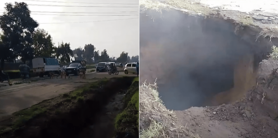
The Kenya National Highways Authority (KeNHA) has announced a traffic disruption along the Nakuru–Kampi Moto Road, specifically on the Kampi ya Moto (B17) Road section.
The affected section is at Kiamunyi near Riva Petrol Station, about 1.5 km from the KFA Roundabout.
The affected area is also part of the London-Kabarak Road in Nakuru County.
This disruption has been caused by the emergence of a sinkhole in that area, and maintenance works are currently underway to address the issue.
KeNHA Announces Traffic Disruption on Nakuru–Eldoret Highway
Motorists travelling to and from Nakuru, Eldoret, and Baringo have been advised to use the diversion road as directed by police and traffic marshals on-site.
For safety, motorists have been directed to approach the affected section with caution, adhere to the traffic signs displayed, and follow the guidance provided by the traffic marshals and police at the scene.
The huge sinkhole caused traffic snarl up along the London-Kabarak highway in Nakuru County on Wednesday April 30 morning’.
Videos circulating online showed curious onlookers gathering around a large sinkhole that was gradually filling with rainwater.
Some residents gathered around the hole as traffic marshals diverted motorists who attempted to use the section of the road.
Also Read: KeNHA Announces 3-Month Traffic Disruption Along Mombasa Road
What Causes Sinkholes?
Residents of Nakuru have been grappling with sinkholes and fissures, a recurring phenomenon that continues to stir anxiety and confusion in the community.
In May of 2024, prolonged heavy rains displaced over 500 families in Kaptembwa, as massive sinkholes and fissures destroyed homes and devastated large areas of land.
Nakuru, located within the Great Rift Valley—a region extending from the Horn of Africa to Mozambique—sits on some of Africa’s most unstable soils, according to geologists.
Also Read: KeNHA, KALRO Announce Mass Auction of Vehicles & Assorted Items; How to Bid
Dr. Clement Lenashuru, a Natural Resource Scientist, told Citizen TV that the area’s instability is attributed to volcanic activity during the formation of the Rift Valley, leaving a layer of pumice or volcanic ash that covers numerous fault lines.
“Beneath the surface, the region consists of loose ash sand, which can be easily washed away by water percolation,” Dr. Clement explained.
He further explained that the Rift Valley’s fault lines are not uniform in size, which contributes to the frequent formation of sinkholes, especially during heavy rains or poor drainage.
Geologists have repeatedly warned that the rapid construction of skyscrapers in Nakuru could be a disaster waiting to happen, as the unstable ground may fail to support the weight in the event of a natural disaster such as a landslip or an earthquake.
Follow our WhatsApp Channel and X Account for real-time news updates.
